
Last ridden in June-July, 2002
Partial trips 1998, 2001
This page last updated : May, 2015
Bicycle the Way of Saint James of Compostela in France
Vélo sur le Chemin de Saint Jacques de Compostelle
Camino Santiago in Francia en bicicletta
Cycling from Le Puy-en-Velay, France, to Roncesvalles, Spain and Compostela
Time: 2 weeks Difficulty: Mainly Hard Bike Rating:: Superlative
General Information:
<Link to Detailed Bicycle Itinerary
- PartA - Days 1 to 6>
<Link to Detailed
Bicycle Itinerary - Part B - Days 7 to 13 and after
Nature of the Ride: This beautiful, 420 mile (700 kilometer) bicycle trip, in central and southwestern France follows the famous pilgrimage route, in use for 1200 years, that leads eventually to the city of Compostela in western Spain. There are four branches of the Pilgrimage route in France that lead from different parts of Europe. This route, which in ancient times serviced travellers from northern Italy, Switzerland, and Germany, is the most beautiful of the routes, and also the one which best captures the experience of ancient times. Unlike the Camino in Spain, which is often overrun, this part of the pilgrimage route in France gives opportunities for solitude.
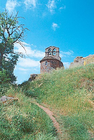
You will ride in picturesque rural, very hilly—even mountainous country, rarely visited by tourists, through forests and rangelands, and alongside pastures, vineyards, and farms. Every day you will encounter handsome, unspoiled, often ancient villages, and meet other travelers who are going the same way. You will also come upon a number of stunning, wonderous first-class churches, monuments, and works of art. Your route will be almost traffic-free roads (except for moderate traffic in eight larger towns)
Difficulty: Make no mistake: Much of the route is extremely hilly, with long, fairly steep climbs. However, if you wish, you can arrange to have your baggage transported. After the long physical effort to climb, you will be rewarded with some wonderful ridge rides and breathtaking, long and fast descents.
 Length: You
can comfortably and enjoyably complete the French Way of St.
James, including your transportation to and from the route, in
two weeks. With only one week to ride, you should
start at the beginning in Le Puy-en-Velay, and continue to Figeac
or Rodez, one of the best parts of the route. You can take up in a future year from where you leave off.
Length: You
can comfortably and enjoyably complete the French Way of St.
James, including your transportation to and from the route, in
two weeks. With only one week to ride, you should
start at the beginning in Le Puy-en-Velay, and continue to Figeac
or Rodez, one of the best parts of the route. You can take up in a future year from where you leave off.
The Travelers : Most travelers undertake the Saint James (Saint Jacques in French) pilgrimage on foot, usually following from Le Puy-en-Velay and proceding into Spain on the French signposted walking route, Grande Randonnée ( = long trail) 65 (GR-65) . Among the travellers, perhaps almost one-half are true pilgrims and their pilgrimages normally are memorable and successful. However, you do not need to be a religious pilgrim; a majority of travelers are not: Many travelers make psychological pilgrimages. Others are adventurers or sightseers.
The Experience: This trip is difficult, but marvellous. It is a "trek"or an expedition or a pilgrimage, but it is also more: There is the sensation of following a long-beaten path— moving not only in the company of the many others who you meet or see along the way; but also, somehow, commuting with the literally millions of people who walked or rode horses the same way 600—800—1000 years ago.
You absolutely should take this bike route if you do take pleasure out of difficult terrain, enjoy a life close to nature, and, perhaps less important, if you appreciate beautiful religious medieval art and architecture.
Given the difficulty, the miles to cover, the relative isolation from luxury and mass-tourism, and the presence of many others who are going the same way— the non-religious as well as the religious may feel on this bicycle journey that they are part of something greater than themselves. You learn something on this trip— something maybe about spirituality, maybe about life, or maybe about yourself. And once you have returned home, you will have a great sense of accomplishment and indelible memories.
History: About a millennium ago, and for four hundred years thereafter, countless Pilgrims walked across Europe. They went to Rome, and to Jerusalem when possible, but also very often to Compostela, Spain, in order to visit there the tomb of the Apostle Saint James, miraculously discovered in the year 820. Saint James, known as Saint Jacques in French, and Santiago in Spanish, inspired Christian warriors—some say appeard in the sky in armor on horseback — and led them—to victory in their battles with the Islamic Moors. Santiago—St. James— became Spain's patron saint.

From all over Europe, pilgrims uprooted themselves to walk to Compostella, and home again. Pilgrims without means were lodged for nothing, while the rich made large donations to the churches and hospitals. It is said that during the 12th to 15th centuries, as many as several thousand persons per day (one-quarter to one-half million persons per year) undertook the various Compostela pilgrimages. This astonishing number (given that approximatley 50 million people lived in Europe in 1300) is credible to the author, considering the capacities of the cathedrals and churches built along the various routes to welcome them.
Pilgrims coming from the rest of Europe followed four ancient pilgrims routes across France toward Compostella : the Route of Paris, the Route of Vézelay, the Route of Le Puy, and the Route of Arles. All along the pilgrimge routes, cathedrals, churches, monasteries, hospitals and chapels—founded by religious orders and backed by rich patrons— contained exquisite and unusual artistic creations. Given the basic life of most people in the middle ages, these edifices were not only for worship and acquiring grace, but were for viewing the art and the architectural masterpieces of the day. We can analogize, in part, the religious pilgrimages of a millennium ago to today's "pilgrimages" of tourists—to see cathedrals, art museums, palaces, gardens, and modern architecture.
 The
Way of Saint James today: After 600 years of disuse,
a rapidly increasing number of pilgrims (now numbering
over 100,000 each year), both religious and laic, travel the St. Jacques pilgrimage routes. Of those who pass through France (about 15,000 or 750 to 1000 persons per day in 2017), the greatest number use the Route of Le Puy-en-Velay, perhaps because the first pilgrim to Compostella was the bishop of Le Puy, in 951, but probably also because the Le Puy route is the wildest and most beautiful. It is the route which best provides the experience and the feeling of a pilgrimage a millenium ago. This route is called the Via Podiensis.
The
Way of Saint James today: After 600 years of disuse,
a rapidly increasing number of pilgrims (now numbering
over 100,000 each year), both religious and laic, travel the St. Jacques pilgrimage routes. Of those who pass through France (about 15,000 or 750 to 1000 persons per day in 2017), the greatest number use the Route of Le Puy-en-Velay, perhaps because the first pilgrim to Compostella was the bishop of Le Puy, in 951, but probably also because the Le Puy route is the wildest and most beautiful. It is the route which best provides the experience and the feeling of a pilgrimage a millenium ago. This route is called the Via Podiensis.
Pilgrims and other travellers start at Le Puy-en-Velay or even farther away in Switzerland or Germany, and most often walk, but also ride on a horse, on a mule or on a bicycle towards Compostele.On foot, it takes a month or more to cross France from Le Puy, walking often seven or eight hours per day, and another good month to cross Spain. Many walkers do only part of the route—typically a week or ten days worth, planning to return in a subsequent year. Others complete the entire route in one fell swoop. Catholic Church officials are said to accept as religious pilgrims those who walk at least 100 kilometers, ride donkeys or horses more than 200 kilometers, and cycle more than 300 kilometers .
The routes of today's walking pilgrimages on trails, paths, and roads sometimes correspond to the routes that ancient pilgrims walked, sometimes not. Ancient bridges have crumbled or washed away; ferries no longer cross broad rivers; roads have dissappeared; paths have become national highways.
Nonetheless, in walking, cycling or riding the Way of Saint James, the modern walker, rider or cyclist can feel much of what the early pilgrims and other travelers felt, see much of what they saw, and contemplate as they contemplated. Whether or not you wish to do so, you will likely learn something, perhaps about yourself, perhaps about life, perhaps about spirituality.
 Attractions: The "wonders" of this trip, as you might expect, consist of cathedrals, churches, and religious art, but also of 25,000 years old cave paintings, Roman mosaic floors, picturesque villages and towns, and military architecture. The historical and artistic aspects of the pilgrimage will appeal to many. For the religious, there are many sites for veneration.
The trip also provides exhilarating of riding in hilly country; a variety of terrain and architectural styles is seven different French departments plus four more, if you continue across Spain; enjoyment of natural beauty away from crowds; and very good food and drink, including duck, foie gras, and armagnac. If you are looking for an easygoing trip, flat country, bicycle paths, many fine restaurants, luxurious hotels, and nightlife, this trip is not for you.
 When
to go: The least chance of rain is between May and September, but if this is not possible, then go in April or October. In winter, the passes can
be blocked by snow; and it snows frequently in the highlands. Mid-July
and August have the driest weather, but afternoon temperatures can
reach 100° F (37° C) in the middle part of the ride in enclosed
low-altitude river valleys. An ideal time to ride the French Chemin is in late May or June. You will have less chance of hot
or cold weather, and you will rarely have to reserve in advance,
as the main tourist season will not have started. (Note: Since I first wrote this page in 2002, the number of Pilgrims has been increasing each year, so advance reservations may now be necessary. Call some lodgings to find out.) Nor will accommodations
be filled by pilgrims who are planning to do the entire Chemin
- Camino on foot, through both France and Spain, as they will have chosen
to cross France in April and May, or in September and early October,
to avoid the summer in Spain. Thus perhaps you can have the luxury of playing
it by ear.
When
to go: The least chance of rain is between May and September, but if this is not possible, then go in April or October. In winter, the passes can
be blocked by snow; and it snows frequently in the highlands. Mid-July
and August have the driest weather, but afternoon temperatures can
reach 100° F (37° C) in the middle part of the ride in enclosed
low-altitude river valleys. An ideal time to ride the French Chemin is in late May or June. You will have less chance of hot
or cold weather, and you will rarely have to reserve in advance,
as the main tourist season will not have started. (Note: Since I first wrote this page in 2002, the number of Pilgrims has been increasing each year, so advance reservations may now be necessary. Call some lodgings to find out.) Nor will accommodations
be filled by pilgrims who are planning to do the entire Chemin
- Camino on foot, through both France and Spain, as they will have chosen
to cross France in April and May, or in September and early October,
to avoid the summer in Spain. Thus perhaps you can have the luxury of playing
it by ear.
Certain years are designated as Holy Years (or Jubilee Years) for the St. Jacques pilgrimage, such as 2010 or 2021, when St. James Day (July 25) falls on a Sunday. True pilgrims completing the route in a holy year are granted by the Catholic Church a "plenary indulgence", and many, many more pilgrims (several times more) follow the St. Jacques Route in these years. Non-Catholic travellers ought to avoid the St. Jacques route during Holy Years.
Continuing to Spain and when to cycle there: This site provides detailed information only on the "Chemin" in France. Many cyclists will continue on into Spain. The additional biking distance will be the equal to that ridden in France—about 440 miles (738 kilometers), measuring from the Pyrenées pass near Roncesvalles. Although this site does not cover the Spanish Camino de Santiago, you will find references here to books and Internet sites that provide the necessary information to follow the standard Spanish biking route (in Spain there is a standard route).
 If
continuing in Spain, strongly consider avoiding July and August there.
It will be quite hot, and the trail and accommodations will be
overcrowded with Spanish tourists and teenagers. Many, many more persons walk
the Spanish camino than the French chemin, partly because Santiago is the patron saint of Spain, and also because
you end up at Compostella with a much shorter walk.
If
continuing in Spain, strongly consider avoiding July and August there.
It will be quite hot, and the trail and accommodations will be
overcrowded with Spanish tourists and teenagers. Many, many more persons walk
the Spanish camino than the French chemin, partly because Santiago is the patron saint of Spain, and also because
you end up at Compostella with a much shorter walk.
None the less, the author has talked to several people who did walk through Spain during July, and who had a wonderful experience, but this was before frequentation doubled or trippled. If it is not a jubilee year, and if you don't mind hot weather, and if you are planning to stay in hotels and are willing to reserve in advance, or to sleep on gymnasium floors, then crossing Spain in the summer is feasible.
Finding accommodation in gites or campgrounds is very competitive in Spain (i.e., said to be almost impossible), but many nice, small hotels may have available space. Avoid the "wave" of walkers that leaves Roncesvalles towards the beginning of the months of July and August (vacations usually correspond with months) and arrives at Compostella towards the end of the same month. As a cyclist, it is probably best to leave Roncesvalles a few days before the end of June or July. It is impossible to obtain reservations in Pamplona, even at many times the normal price, from July 6th to 14th, due to the running of the bulls, and you must circumnavigate the city. If you are considering walking in Spain in the summer, I suggest that you carefully research the experience and the lodgings.
How to Bike The French Le Puy route— Organize the trip yourself. (Several bike touring companies cover part or most of El Camino de Santiago in Spain.)
I do strongly recommend that you organize your own trip, alone or with a very small group of friends, so that you gain the benefits of discovery, exploration, and contemplation that a "pilgrimage" provides. I believe these aspects will be lost in a big groupand additionally you will probably miss some of the most interesting sites.
Many, many additional photos of the Saint
Jacques route may be seen in the detailed itinerary. Click on the
following URLs:
<Link to Detailed
Bicycle Itinerary - Part1>
<Link to Detailed
Bicycle Itinerary - Part 2>
Organizing the trip yourself:Unless otherwise noted, traffic on this tour is expected to be "light" or "very light". Please follow this link for an explanation of the author's traffic ratings. Please refer to the links on the Home Page for important background on costs, touring styles, transportation, bike types, rentals, maps, information sources, traffic ratings, packing, and security and safety tips. Refer to this page for information on French pronunciation, French bicycle nomenclature and French road signs.
Le Puy is accessible from Paris on trains that carry assembled bicycles in four and one-half to five hours. See the page Trains and Bikes for more on French train options. Another alternative for small groups used to e to rent a car or mini-van, and put your bike inside or on a rack. Hertz used to provide one day, one-way rates within France of 100 - 150 and drop charges under 100 (2014), and as ageny in Le Puy (a drive of approximately 6 hours from Paris). But as I write rates have more than doubled because of the pandemic. So check it out. Rates would be lower, and particularly attractive, (for those living outside the European Union) in conjunction with a French rail or Eurail pass. Other car companies may have similar or better deals. In comparing alternatives, don't forget the costs of tolls and gas (petrol), which are high in Europe. Ending point: Roncesvalles, Spain (in the Pyrenees) with a return by bicycle (27 km - 16 mi), almost all downhill) to St. Jean-Pied-de-Port, and train service to Bayonne carrying assembled bicycles. From Bayonne, you can take a TGV to Paris with your assembled bike in under 5 hours. British travelers, for both the outbound and return trips, should check for possible air and bus alternatives with the Confraternity of Saint James (see below), either directly or through their Pilgrim Guidebook. I continued my biking trip for an extra day to the Pays Basque coast of France (to Biarritz***), or one could continue to the Atlantic coast further north. I give routing suggestions on the last itinerary page. Optional Spanish ending points: Pamplona***, Compostella,*** or or other Spanish cities, with Spanish regional trains eventually connecting to Bayonne. In Spain, as long as you limit yourself to regional trains, you can carry a bicycle on (you may have to insist). From Pamplona there are regional trains leaving for Alsausa in the morning, afternoon and evening. You can transfer to another regional train going to Irún, on the Atlantic at the French border. The total trip on regional trains takes, as of this writing, 3 to 4 hours. (There is direct train service twice a day from Pamplona to Saint Sebastian, but bicycles are not permitted.) From the border TGVs run to Paris. The address of the Spanish railway is http://www.renfe.es. Click on "English", "Timetables and Price", and "Regional". Now you should select "Norte" or the orange top box on the map. Under Vittoria-Pamplona-Castejón select Pamplona as your departure city and Alsausa as your arrival city. Jot down the train times. Now under the line Miranda-Vitoria-Irún, find trains that make connections from Alsausa to Irún. Probably the best way to return from Compostela or elsewhere in Spain is by air. Iberia has inexpensive flights, and the baggage charge for a bicycle is under €100 at this writing. Length of the Ride: About 700 kilometers (420 miles) plus possible side trips. To ride from Le Puy-en-Velay to Roncesvalles will take you approximately two weeks. This includes one rest day, but you may wish to allow others. If you wish to divide up your trip, logical sections are: From Le Puy to Figeac—5 or 6 days (to Cahors 6 or 7 days). From Figeac to Moissac—2 or 3 days. From Moissac to Saint.-Jean-Pied-de-Port— 5 to 7 days. Each of these logical starting and stopping points is served by rail and automobile rentals. From the Figeac or Cahors you can take your assembled bike directly back to Paris in one day. Other points with train service are Aumont-Aubrac, Decazeville, Lectourne, Eauze, Nogaro, Aire-sur-l'Adour and Orthez. (This train information may be out of date. Check.)
Accommodations: In the season it appears to be essential to reserve a few days ahead or more. Lodgings include hotels; gites d'étape (very frequent along the Saint Jacques Way, often run by municipalities, with Spartan bunk rooms, sometimes also spartan double rooms, cooking facilities, and occasionally, meal service); chambres d'hotes (lodging in or nearby private homes, sometimes mealsnot mentioned in this site's itinerary but listed in guide books, specifically the Miam-Miam-Dodo book discussed below or the huge general guide published on this type of lodging; or by Internet search); rental rooms, sometimes in someone's house (chez l'inhabitant); occasionally religious accommodations provided by the Catholic Church or lay groups; and campsites for your tent. The Miam-Miam-Dodo book described below lists all accommodations that are right on, or near the Chemin, including the chambres d'hotes, with prices. It also notes which gites and other accommodations accept horses and donkeys. It appeared to the author that most walkers and riders on the Chemin, regardless of their means, usually chose to stay in the gites d'étape. The pluses of gites are conviviality and low price. The minuses are conviviality (if you don't want it), communal facilities, lack of any luxury, and crowded sleeping.
Tip: From April to September, pilgrims ( and holiday visitors) can be numerous. While only 2,000 "pilgrims" a year arrived in Santiago, Spain in 1986, approximately 60,000 arrived in 2001 and 145,000 in 2009 and more than 300,000 in 2019. According to the two owners of the baggage transportation companies (see below) it can be essential to make your sleeping reservations five or more days ahead. There is, or used to be, however, a hiatus in June, when it is/was not necessary to reserve in advance. The year 2021 will be a "holy year" when all sins are absolved , and the number of pilgrims is expected to multiply. (See the Confraternity Site described below for more information.) Tip: If you are planning to stay in Gites, which usually provide blankets but not sheets, you will need to carry with you a sleeping sack, which you can buy for about $20 to $30 (try REI.com in the category "sleeping bag liners" or Eastern Mountain Sports). These poly-cotton commercial items weigh, however up to 1.5 pounds. You may prefer to fashion your own "sheet" out of light weight polyester or nylon. The author, for very little money and time, once fabricated a double-long "sheet" that folds into two twin size bed sheets. It takes up very little room, and weights only 4 ounces; on the downside, it is a bit noisy (crinkly) and less comfortable than cotton. Lodging phone numbers and addresses can be found in the guide books mentioned below, or on the Web (by a town search) or in general accommodation guides. I strongly recommend, using the Miam-Miam-Dodo guidebooks, as they greatly simplify the task of finding accommodations. Tripadvisor.com provides traveller rankings of hotels and restaurants in the larger cities and town.
If you are continuing into Spain, you may wish to obtain the specific pilgrim passport (credential) used there, which gives you the right to stay at the Spanish gites (refugios); it is issued in Saint-Jean-Pied-de-Port or Roncesvalles. It may be that French passports are now accepted in Spain for that purpose. Check with the pilgrim welcome office in Saint-Jean. The GR65: The "GR65", or the "Grand Randonée 65 is the name of the "standard" French long-distance "Saint Jacques" walking route of today between Le Puy-en_Velay and the Spanish Frontier. Most all walking pilgrims choose to follow this route. Signposts marking the GR65 display the typical GR markings—a white rectangle over a red rectangle, with arrows for turns and Xs to indicate errors. However, signposts on the GR65 also often display a pictogram of a scallop shell, the symbol of Compostela. (In point of fact, the scallops one eats in France are named coquilles Saint Jacques—Saint James shells). Warning: On some parts of the route, businesses have put up scallop shel signs that lead off to minor tourist sights or villages. It is good practice to rely upon the GR white and red markings. The GR 65 walking trail was originally laid out by a combination of departmental tourist organizations, non-profit organizations, and local governmets. Where possible, paths or minor lanes follow close to the original pilgrimage routes. The GR65 avoids highways, even though many highways of today were once the paths followed by the ancient pilgrims. The GR65 walker, even if the his routing on the GR65 is different from the ancient pilgrimage route, has a physical, psychological, and spiritual walking experience that resembles (at least in part) that of the early pilgrim. (It is interesting to note that many walkers in ancient times often averaged 60 kilometers (36 miles) per day, similar to the distance a road biker might choose to cover nowadays.) Horse and donkey riders, as well as mountain bikers, can utilize many, but not all, parts of the GR65 walking path. Road bikes can only occasionally use the GR65 walking route– when it corrsponds with roads, and lanes. Baggage Transportation: If you are locked into specific reservations, or can definitively plan at least a day ahead, then perhaps you will wish to pay for baggage service and carry much smaller and lighter paniers. I spoke with two companies providing baggage transportation along the Le Puy to St. Jean-Pied-de-Port itinerary. Transbagages, tel 04-66-65-27-75 (office), 06 80 06 32 19 (cell) , info@transbagages.com, operates between Le Puy and Condom (and possibly as far as St. Jean Pied de Port., and charges (2002) 7 € for each suitcase per day (call a day ahead between 4:00 PM and 7:30 PM). The author confirmed from several sources along the way that Transbagages is considered very reliable. Factage, tel. 05-63-94-75.60, operates between Le Puy and Figeac and charges (2011) 7 Euros per day per walking stop (but €14 per day for a typical biking stage of 3 walking stops (call a day ahead between 6:00 PM and 9:30 PM). http://factage.free.fr/The author did not checkup independently on the reliability of Factage. Between St. Jean Jean Pied de Port and Roncevalles the following company assures the transport of baggage for €8 per bag (2011): http://www.expressbourricot.com/en.html Exposure to the Sun: In the months when the sun is highest and when the air is dry, and especially if you have fair skin, strongly consider arising and departing early in the morning. Days are very long, and if you are not careful, you will have ample opportunity to overexpose yourself to the sun and to heat. Catch your breakfast at a café along the route, or buy it at a patisserie. Set your itinerary to arrive by early afternoon. Why a biking Itinerary?: In France, there has been no "standard" or even semi-official routing for road bikers. Therefore, it is necessary for individuals to lay out an itinerary or follow a preexisting one. In laying out the Itinerary which I followed and that I present on this site, I utilized these criteria: to be faithful to the the spirit of pilgrimage, without undue hardship; to use the GR65 and the ancient pilgrimage routes where conveniently possible; to visit the most important religious and tourist sites along the way; and to give a choice of routings if appropriate. (I have read the itinerary presented in the book in English listed below, but believe mine is signifigantly better.) <Link to Detailed Itinerary - Part 1> How to use the Itinerary: The descriptions of the principal religious and tourist sites in the itinerary are mainly for the purpose of planning your daily and weekly schedule . To learn more about these and other sites, you will need to also carry a guide book (see below). It is up to you, of course, to decide how far to ride each day — and where tostop. My choice of nightly stops is based partly upon the religious and touristic importance of the stop, but also the difficulty of the route. In any event, my itinerary mentions the most likely intermediate overnight stops. Do, please, read the itinerary in advance to see how hard each day will be, and so you know which route choice you will take. Do, please, trace your planned routing onto your map(s). This is guaranteed to make your route-finding much easier and less error-prone. This site was created before the day of GPS navigation. If a reader wishes to send way points, I will look at adding them. Is technology appropriate for a pilgrimage which for some may emulate the pilgrims of one-thousand years ago? Unless otherwise noted in the itinerary, if the author's experience is representative, automobile traffic everywhere should be light, very light, or nonexistent—except very near and in eight large towns. (Traffic could perhaps be somewhat heavier during the main tourist season of mid-July to August). <Link to author's traffic rating nomenclature>.
Deciding on the Purpose and Style of Your Trip:Are you a pilgrim? Are you a tourist? A combination? Are you a rider for the physical pleasure or for the exercise? Do you want to meet other travelers, or are you in a self-contained group? How much weight are you going to put on your bicycle? If you are planning to travel along the Route of Saint Jacques as a pilgrim, are you sure you wish to cycle? Obviously, there is a big difference in speed, total time, observation, contemplation and feeling between walking, or riding an animal, or mountain biking, or road cycling. How much money are you prepared to spend? Are you going to eat in restaurants, or cook your own meals. Can you afford hotels?[Note: prices below are far out of date, and now are undoubtedly much higher.] If you stay in Gite d'Etapes (communal living in bunk rooms) or religious accomodations and cook yourself or eat pilgrim menus, you may spend as little as €10 - €15 per day (double that in Spain). If you camp, you can spend even less. Are you going to stay only in hotels and eat in restaurants? Your budget will be many times higher, ranging from € 45 to € 80 per day (double occupancy)(unless you splurge on the rare luxury hotel or restaurant). You need to think all this through in advance, so that you can plan your route, visits, stops, type of accommodations, and clothing, in keeping with your objectives. Information sources about the route in France: It is evident that you will bring the necessary guidebooks and maps with you, or buy them along the way, and that you will plot your route onto the maps (or, as my second choice, onto a GPS) ahead of time. As a biker, because of the hilly country and minor roads of this trip, the author strongly recommends choosing 1:100,000 maps from the IGN: Map nos. 50, 58, 57, 63 and 69, and not using the Michelin or other 1:200,000 maps. (Note: There will be a few kilometers south of Aire-sur-l'Adour where these maps will not have coverage. You can rely upon the directions of the itinerary, or for coverage of these few kilometers you can buy IGN map no. 62.) I do not recommend the Open Street Maps or Google Maps or Apple Maps at this time (2015). Also consider carrying one or two maps with a scale of 1:400,000 or more, in order to see how the Chemin fits within France. If you are a walker, you should carry French guide books for their convenient 1:50,000 maps that you will need (even if you don't speak French), supplemented by one 1:200,000 or more, large-scale map. Using 1:50,000 maps rather than the guide books can be more bulky and more expensive, because of the many maps required. However the guide books do not cover all the area a cyclist will traverse. Guides in English:
Guides in French: An excellent set of three booklets, even if you don't read much French, essential for those planning to stay in hotels, or chambres d'hôtes, or those who have horses or donkeys (and useful to everyone else) is called "Miam-Miam-Dodo. It is available directly form the author, or more easily from the Confraternity of Saint James site described above, or from the French Amazon site, Amazon.fr and elsewhere. Do look at the bottom of the first booklet's Internet page to see sample pages. Miam-Miam-Dodo provides in French some general information, and also a complete hotel and accommodation listing within 5 kilometers of the walking route, with reasonably accurate prices. Each volume weighs 210 grams ( 7.4 ounces), so if you are worried about carrying too much weight, and if you know the type of accommodations you will be staying in, then you might wish to copy information from the Miam-Miam-Dodo book into the Confraternity Guide before you leave. Incidentally, the author of the booklet walked the Way of Saint Jacques leading a mule, which carried all supplies. The root Internet site is a worldwide compendium of information about mules. The French organization FFRP publishes three (consecutive) guides to the GR65—the walkers Route of Saint Jacques (FFRP References #651,#652 and #653) (€16,40 in 2021). Altogether they 540 grams, or about 1 pound . They are very useful for walkers, as they give detailed 1:50,000 maps and detailed routings, a fairly complete list of non-hotel accommodations, color photos, and a discussion of major sites and regions. However, it is not always very clear on the maps when the GR 65 is on a road and when it is not. Also, the bike route can be off of the maps provided. Finally, I believe that Miam Miam Dodo now provides more useful maps, but again, these may not show all bike routes..Thus, bikers will be better served by not using these guides and relying upon the Itinerary given here plus the guides and maps mentioned above. French guides are also available in Le Puy, most other bookstores along the route, and online. For those who read French extremely well and who want an intellectual, and literally, somewhat heavy (literally and figuratively) book, "Le Chemin de St-Jacques, Du Puy-en-Velay à Roncevaux Par le GR 65", published in 1995 has 1:50:000 maps showing the modern route (and its variants) as well as the ancient paths. (16.9 ounces). It contains only a partial list of smaller hotels and hostels, and lengthy descriptions of sights and history from the pilgrim's perspective. A few new and used copies are available at Amazon.fr.
And, for those who read French well and who don't mind the weight (or copy selected pages before you go), the French literary book and/or the 3 topo-guides that provide suseful background information and photos on the land and the history of the Pilgrimage, which, unfortunately, none of the above-named English materials provide. Information Sources about the route in Spain: The Confraternity of Saint James, mentioned above, (http://www.csj.org.uk) sells a booklet on The Camino francés (Spanish route from France to Compostella), another on The Cycling Pilgrim on the Camino francés, and many others. The books from Cicerone press mentioned above cover the Spanish Camino. The following two Spanish Internet sites in English (and other languages) are dedicated to the Santiago pilgrimage, and have a great amount of helpful information for both walkers and bikers: http://www.mundicamino.com (in Spanish, but some english links to click on). Also available are free booklets (still I hope) published by the Gobierno de Navara, Departamento de Industria, Comercio, Turismo y Trabajo and available from the tourist offices in Roncesvalles or Pamplona (and probably elsewhere). It provides detailed information on all the classic stages of the trip. However, these booklets are duplicative of the information available on the Internet. Reader William Anderson writes that his family spent several nights on the floors of polideportivos (gymnasiums) . "I make one strong recommendation -- buy or bring a sleeping pad."They can be purchased in Spain "for about 6 Euros...Fortunately, most of the albergues provided blankets and we survived some other nights...by wearing extra clothing inside our sleeping sheets....Maybe this August was cooler than usual." There are..."numberous challenging stretches if one is trying to stick with the 'camino authentico.' I met an English couple from Kent who were negotiating the up-and-down terrain somewhere west of Pampolona. They both had road bikes and most of their baggage was being ferried ahead by a family member. The man was carrying his and his wife's bikes up the hills...I dont see how they fared off on some of the rougher downhills. Frankilly, I doubt that they perserved (ofroad at least) much beyond where I met them...Some downhills will test even the best of mountin bikes." "In Gallicia, the camino is coded and signed for legs that are (i) suitable for bikes of all sorts, (ii) difficult, or (iii) impossible except by mountain bike (which, even then, might have to be walked)...An English volunteer named John, who cruises the camino each summer...authoritatively informed me...that the only real "camino authentico" was the old Roman road (the calzada), which in many instances was now the paved highway, and that I was taking foolish risks cycling [with a mountain bike] down the steep and rocky sections of the modern camino. Still I am glad I did it." (Reader Anderson, in his email , mentions a couple of injuries requiring stitches, one involving his family, on a steep part of the trail.) Much of the standard Spanish Santiago route for road bicycles is on busy national highways, with one-meter-wide bike lanes. <To Part 2: Bicycle
Itinerary for the Route of Saint James - Part 1>
|
 Starting
and Ending Points:
Starting
and Ending Points: Bike
Rentals: It would be impractical
to rent a bicycle for this one-way journey from Le Puy, particularly since a good quality rental is impossible to find in Paris. The best possibilities are to buy and resell a bike, or bring your bike
from home. See the general discussion of renting on
Bike
Rentals: It would be impractical
to rent a bicycle for this one-way journey from Le Puy, particularly since a good quality rental is impossible to find in Paris. The best possibilities are to buy and resell a bike, or bring your bike
from home. See the general discussion of renting on 
 Pilgrim Passport (Créanciale):
 The Confraternity of Saint James, a UK charity (
 Summary: Therefore, for bikers, I strongly recommend carrying (1) the Miam-Miam-Dodo
book if you are staying in hotels or chambres d'hôte or campsites or might
do so or wishing to provision yoursel); (2) the 1:100,000 IGN
maps enumerated above;and (3) the
itinerary that follows on this Site (of course!).
Summary: Therefore, for bikers, I strongly recommend carrying (1) the Miam-Miam-Dodo
book if you are staying in hotels or chambres d'hôte or campsites or might
do so or wishing to provision yoursel); (2) the 1:100,000 IGN
maps enumerated above;and (3) the
itinerary that follows on this Site (of course!).